Roscoe's solution (Part thereof)

In Geography Strabo (64 B.C-23 A.D.) tells of a massive 300 tons of gold and silver bullion that was recovered by the Romans from the Celtic temples at Narbonne. This is near the mouth of the Aude river on the French Mediterranean coast. A further eighty kilometres up the Aude is Rennes-le-Chateau. Strabo attributes the bullion as either an accumulation of Celtic sacred offerings, or else the Celts' loot from the Greek treasuries at Delphi, sacked in 278 B.C. The Romans somehow lost the bullion near Narbonne during Caesar's Gallic Wars and it was never recovered.
The gold was taken from a votive lake by a Roman proconsul by the name of Cæpion. He took 80 tons of gold and money and immediately re-melted this into ingots. This apparently disappeared during its transport towards the port of Narbonne following an attack from Volkes tectosages upset by this profanation of their sacred offerings. They would have then withdrawn to the high valley of the Aude and would have hidden the treasure in this area which is easy to police.
In 1830 a man while out walking in the Garrigue found a gold ingot weighing 20 kilos and not long after this in 1860 near to Bezu another man found a gold bar made up of partially smelted Arabic coins and weighing almost 50 kilos. Sauniere was investigated by the local Gendarmerie on suspicion of trafficking in gold in Spain and there is also a report from Spanish police on this matter.
Additionally there is the story of a shepherd boy from the 17th century who had lost a sheep and found it had fallen down a pit and crawled down to recover it only to find hoards of treasure there. This pit is said by some to be located at La Soulane, the most eastern point of Lincoln's pentacle of mountains. There are in fact many pits around La Soulane.
Soulane is an Occitan word associated with the Sun.
The votive lake is this one.
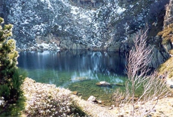
Described as Otto Rahn's Grail lake.
It is called Etang des Truites. There is no trout in this lake and there never has been, trout cannot survive at this altitude. There is however an endemic species of Golden Salamander. The word Truites is a corruption of the word Druides. It is described as Otto Rahn's Grail lake and the lake sits above another lake called Etang du Diable (Devils Pond). The lakes are on the slopes of Batholmey and Soularac (Solar Rock) - Initials BS.
They sit on the Archangel's Cross.
They are 5 miles from Montsegur and joined by a track known as Trac des Grailles. Montsegur is known locally as Mount Tabor which had been the place of the Transfiguration of Jesus. The feast of the Transfiguration is the much older Celtic feast of Lughnasagh, named after the Celtic Sun God Lugh. The city of Lyon was named after this same Sun God.
It is important to state that the Cathars only occupied Montsegur as a result of attacks by the Holy Roman church. At the fall of Montsegur in 1244 they had only been there 40 years. Prior to that it had been a Solar Temple.
From Shellenberger and Andrews. The kneeling blue shepherd's staff makes the pentacle, the white shepherd's staff makes the six sided figure inside the circle. Try to extend the Red Shepherd's staff to the same circumference and see what you get. All are centered on the rock shown right.
In February 1944 SS Colonel called Otto Skorzeny the same man who had rescued Mussolini in a daring mountaintop raid and a selected unit of SS commando set up camp at Montségur itself. Montségur is approachable on three sides, Skorzeny and his team decided to scale the sheer drop of several thousand feet. After abseiling down the vertical face they allegedly found a walled up cave. Skorzeny sent a message to Berlin:
“Ureka”
And signed it – “Scar”
The reply was:
“Well Done. Congratulations. Watch the sky tomorrow at Noon. Await our arrival”
Reichführer
It was March 16th 1944; it seems that Skorzeny had unwittingly found something on the 700th anniversary of the fall of Montségur and was surprised to come across a large gathering of Cathar descendants heading for the Castle to pay homage to their ancestors. It was significant because an ancient prophesy had foretold that at the “end of 700 years, the laurel will blossom again on the ashes of the martyrs”.
The signal to watch the sky when Skorzeny and his team arrived at the castle at noon was significant because German aircraft arrived and formed a Celtic cross in the sky. The following day Reichsminister Alfred Rosenberg and Colonel Wolfram Sievers of the Ahnenerbe arrived at Montségur to congratulate Skorzeny.
The treasure found apparently consisted of:
• Thousands of Gold Coins
• Items believed to have come from the Temple of Solomon, which included Gold plates and fragments of wood which had once made up the Ark of Moses….a gold plated table, a candelabra with seven branches, a golden urn, a staff, a harp, a sword, innumerable golden plates and vessels, many small belts of gold and a number of precious jewels and onyx stones, some of which bore inscriptions.
• Twelve stone tablets bearing pre-runic inscriptions which none of the experts were able to read.
• A silver cup with an emerald-like base made of what appeared to be Jasper. Three gold plaques on the cup were inscribed with cuneiform script in an ancient language.
• A large number of religious objects of various types…crosses from different periods which were of gold or silver and adorned with pearls and precious stones.
• Precious stones in abundance in all shapes and sizes.
Many of the gold coins were melted down and turned into ingots. When the town of Merkers fell to the 3rd US Army under General George Patton his men discovered these ingots in nearby salt-mines in which this treasure was stored. The estimated value of the gold was $250,000,000 (by 1945 estimates).
As mentioned earlier Montsegur is known locally as Mount Tabor which had been the place of the Transfiguration of Jesus. The feast of the Transfiguration is the much older Celtic feast of Lughnasagh, named after the Celtic Sun God Lugh. The New Testament presents three almost identical accounts of the Transfiguration in three of the synoptic Gospels; Matthew 17:1-9; Mark 9:2-9; and Luke 9:28-36, significantly it does not feature in the Book of John. To reiterate the story these Gospels tell us that Jesus went up onto a mountain (Mount Tabor), with the disciples Peter, John and James, and in their presence Jesus was transfigured shining like the Sun and then there appears Moses and Elias (Elijah). It is interesting to note here that the painting by David Teniers which we have been calling St Anthony and St Paul fed by Ravens is listed in the Witt Library catalogue at the Courtauld Institute as Elijah and Elisha being fed by Ravens. This is odd as the painting clearly has a crucifix on the rock at the centre yet those are prophets from the Old Testament and equally odd is the fact that Elisha was never fed by ravens although Elijah was fed bread and flesh after God had sent him into the desert. In the New Testament, both Jesus and John the Baptist are on some occasions thought to be Elijah. John the Baptist was actually described by the Archangel Gabriel as coming "in the spirit and power of Elijah" .
The birthdays of both John the Baptist and Jesus are significant Celtic festivals. John the Baptist day being Midsummer's Day and Jesus' being the Winter Solstice.
So then we have this:
"My dear Roseline, who died on 6 August 1967, the Feast of the Transfiguration, while leaving the Zero Meridian by car." (p. 108).
“Two contrary desires share my heart, glory to publish all that at the great day, and to jealously keep this treasure without ever saying anything. My whole life needs to hesitate and I awake in the same moment that I die….. By the celibacy which is imposed on them the priests are the best guards of treasures than one can conceive…..A priest, because it is concerned [with] Sky and Earth, must meditate on the relationships of astronomy with the geography…..With the difference in the phenomena which should be seen to believe, Cromleck of RLB [Rennes les Bains] is seen only when one believes in it, nothing is really proven there, not even the roulers or hones it posed which will appear readily to the whims of nature.”
- The words of Philippe de Cherisey.
The Abbé de Fleury was born in Lodève in the Languedoc in 1653 and was the bishop of Fréjus in 1698 and became the preceptor for the young King Louis XV in 1715. He was a member of the Academy of Sciences and was a Cardinal and Prime Minister by 1726 at the age of 73. He extended the library for the King but interestingly he sent many of the members of the Academy of Sciences to the North and to Peru to measure the meridian. He also sent scholars to Egypt and Greece to search for precious manuscripts.
Interestingly Soularac is mentioned in a report of a meridian measurement by the well respected astronomer Delambre in 3 volumes of work from 1806 to 1810 that followed ground measurements in 1797 by Méchain here it is referred to as Eastern Peak of the Saint-Bartholémy Mount and the “Peak of Estangtost”. Delambre was born in Amiens in 1749 and was an astronomer and mathematician; he was a remarkable man who had a childhood illness which gave him the fear that he would soon go blind. As a result of this he read every book that was available to him and immersed himself in Greek and Latin literature. He also acquired the ability to memorise entire pages and to recite them verbally word for word. He also became fluent in Italian, English and German and even published a book called “Rules and methods to easily learn English.”. However his interest in astronomy is quite relevant to our story and Delambre’s contribution to the science of Astronomy is so great that he has a crater on the moon named after him.
Delambre published details of the whole project in Base du système métrique. The first of the three volumes, containing the history of measurement of the Earth and the project's triangulation data, was published in 1806. When Delambre presented it to Napoleon, the emperor said:
“Conquests will come and go but this work will endure”
In 1809, Napoleon requested that the Académie des Sciences award a prize for the best scientific publication of the decade, the award went to Delambre for his work on the meridian.
The very word meridian seems to have a curious etymology and can be associated with the name Mary or Mari and is of course any line drawn the shortest distance around the earth’s surface from the North Pole to the South Pole. This would be designated as a datum line usually given zero degrees from which the West/East circumference would be segmented into 360 equal degrees. So each hour the earth will rotate 15 degrees. The word Meridian is largely thought to have stemmed from the Old French word for noon, literally medhyo-dyeu - mid day. However the word dyeu, although now taken to mean day is in fact directly from the word for god and the same base from which the Latin word dei stems. The name for the Indo-European God Jupiter is from the vocative compound dyeu – pater (God father) and Diana is from the Latin Diā – na (literally Moon Goddess). Even Asmodeus is from Aēšma-Daēva, which if we are to translate literally using Zoroastrianism is literally Wrath of God from the Avestan old Persian language. The marking of the meridian is therefore directly linked to a god or goddess and taken literally could in fact mean the Goddess Mari – Mari-dyeu.
And finally this:
Mesures altimétriques: un point géodésique de "premier ordre"
Après une mesure ponctuelle de notre pic par François de Plantade durant le premier tiers du XVIIIe siècle, les premières mesures géodésiques visant à effectuer un "nivellement général", c'est à dire une détermination de tous les principaux sommets de la chaîne des Pyrénées, remontent aux travaux du géodésien H. Reboul, assisté de l'astronome J. Vidal, entre 1787 et 1789.
Dès ces premières mesures géodésiques, le Pic de Saint-Barthélemy a été considéré, de par son panorama, comme "point géodésique de premier ordre", c'est à dire un point nécessaire à la triangulation principale. Pour le Pic de Saint-Barthélemy, Reboul avait trouvé une élévation de 2322.5 m par des mesures effectuées le 9 septembre 1789 "à la Montagne d'Appy, Tabe, ou St-Barthélemy", et vérifiées par Vidal (cela ne rehaussait que de quelque mètres la mesure de Plantade qui était de 2319 m). Ensuite ces deux mêmes scientifiques avaient entrepris une nouvelle campagne de mesures, plus précise, entre 1816 et 1817, dont les résultats ont été cités par plusieurs auteurs. Le statut de "point géodésique de premier ordre" dont a joui dès le début le Pic de Saint-Barthélemy, fait qu'il a été toisé à chaque nouvelle campagne de mesure.
Ensuite, il faut savoir que le Pic de Saint-Barthélemy a reçu l'insigne honneur de faire partie de la petite centaine de points remarquables choisis de part et d'autre du "méridien de l'Observatoire" pour mener à bien "la mesure du monde", comme disaient les révolutionnaires, ceci afin de définir une unité de longueur totalement nouvelle et "universelle": le mètre.
On the western slope of Soularac/Bartholemy can be found the rare earth Ruthenium
Ruthenium is an Anti-cancer medicine
Philosophers Stone Anyone?
P.S. of Otto-Rahn.com site's admin: i put it here because name of Otto Rahn mentioned above, but i am not sure it should stay here. I'll read it later
- Vous devez vous identifier ou créer un compte pour écrire des commentaires
Termes similaires

(English)
|

(English)
|

(English)
|

(English)
|

(English)
|

(English)
|

(Русский)
|

(English)
|
Contenu populaire
Aujourd'hui :
Random Lexicon
Renat Nelli (1896 - 1982). The translator of Otto Rahn in France. Founder of the Center for Cathar Studies (Centre d’etudes Cathare) in Carcassonne. One of the major authors of the 20th century in Occitania.
Recommandez-nous sur Google
L'aide est la bienvenue!
Si vous avez des textes, photos, liens sur Otto Rahn qui ne sont pas encore à ce site, ou traductions existantes des matériaux, s'il vous plaît laissez-nous savoir<. Nous sommes reconnaissants pour toute aide pour remplir le site Otto Memorial.
Commentaires récents
il y a 14 années 10 semaines
il y a 14 années 10 semaines
il y a 14 années 10 semaines
il y a 14 années 11 semaines
il y a 14 années 14 semaines
il y a 14 années 20 semaines